


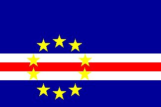
Cape Verde
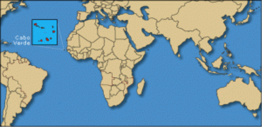
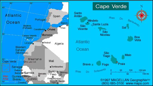
Cape Verde, officially the Republic of Cape Verde is an African island state and an archipelago consist of ten volcanic islands. It is located in the Atlantic Ocean, 640 km west of Dakar, Senegal. Other neighbors are Mauritania, Gambia and Guinea-Bissau, all on the western coastline of Africa that runs from Cabo Branco at Bijagós islands. Interestingly, the Cape Verde which names the country does not lie in it but hundreds of miles east, near Dakar, Senegal.
It was discovered in 1460by Diogo Gomes for the Portuguese crown, who found the uninhabited islands and apparently without evidence of previous human presence. Was a Portuguese colony from the fifteenth century until its independence in 1975.
Santiago Island
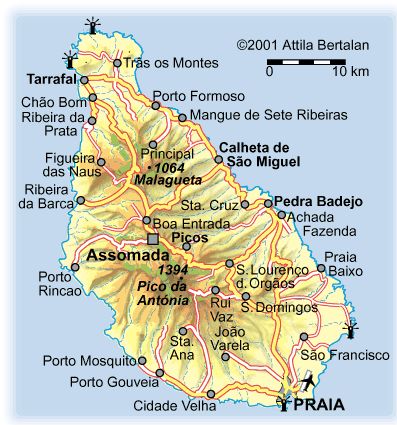
Santiago is the largest island of the archipelago of Cape Verde, which belongs to the Sotavento group. Extends for about 75km long, north to southand about 35km wide, east-west. Area: 991sq km
The island of Santiago, considered the most African of all and where the contrasts are sharper, offers a multitude of mountains and valleys, paths and trails, in what is the largest island of the archipelago and that accommodates half the country’s population.
Cradle of “cabo-verdianidade”, the island offers a unique cultural, culinary and scenic richeness, in addition to beautiful beaches. This is also where you will find the memories of other times, in the silence and in the ruins of Old Town, ancient Ribeira Grande, the first Portuguese city. It also has beautiful bays and coves. The São Martinho, Baixo Beach and São Francisco, as well as the Tarrafal and the Ribeira de Prata, worth a visit … and a mandatory swim. The Sucupira market (popular market) and the vegetable market in Praia also constituted compulsory passages. The city of Praia is also positioning itself as a center for regional and international conferences and events. The island has an international airport and the port connected to the main markets. Come along and soak up the infectious magic of the most African island of the archipelago.
Discover the variety of leisure time in the capital
The artistic multiplicity of Cape Verde has strong expression in capital, the city of Praia. There is a wide choice in terms of restaurants, bars, museums and cultural, sporting and leisure activities.
In many existing restaurants, the cuisine is varied and with unique flavors, offering dishes from typical, as cachupa, to specialties with fish and seafood, accompanied almost always with live music on weekends. Give a ride by Plateau, the historical hub of the city of Praia, and discover the excitement of the legendary restaurant “Quintal da Musica”, which provides unforgettable night and moments of entertainment, flavors, aromas and artistic wealth.
Live here the history and culture of Cape Verde
Santiago is the island of all contrasts, from the balmy beaches, the unique landscapes, the traces of rurality within, through the fragments of history that transport us to distant times. Meet the birthplace of Capeverdean – Old Town – where reigns, imposing, the Fortaleza Real de São Filipe.
Visit Santiago is to discover the roots of country and marks the settlement, while soaking up the morabeza and the frenetic rhythms of drumming. A visit to the community of “Rabelados” (community that was many years isolated from the rest and that kept ancestral ways of life) imposes itself to the visitor. After a pleasant journey through the island, we came to a bay surrounded by coconut trees, which is one of the most scenic beaches in the archipelago of Cape Verde: Tarrafal. The county, located in the north of the island of Santiago, also home to the former concentration camp of Tarrafal, now transformed into a museum. Created by the Portuguese Government in 1936, the Tarrafal Penal Colony, also known as “Tarrafal Field ” was spot during years of atrocities and human rights abuses, until it closed in 1954.
Venture into the unusual inland
Beyond the glow of the capital, Santiago is an island of rugged mountains, lush valleys and volcanic rocks. On this trip the mystic inside, be sure to visit the colorful Assomada market, an important trading point, with a unique atmosphere, a mixture between country and city.
Do not miss also the valley of São Domingos, the Pico d’Antonia (the highest point on the island), nor cease to visit the Botanical Garden of St. George, “Rui Vaz”, the Natural Park of Serra Malagueta, Calheta de São Miguel and Santa Cruz, not forgetting São Lourenço dos Orgãos and São Salvador do Mundo.
São Domingos
The Municipality ofSãoDomingosisa rural county/ municipalityof Santiago Island, Cape Verde, with137.6square kilometersand13,305inhabitants. TheDayof the MunicipalityisMarch 13. Since 2008, the municipality of SãoDomingosis governedby the Movementfor Democracy. Area: 137.6 sq km
São Domingos one municipality with History
The municipality of São Domingos, the gateway to the interior of Santiago’s main tourism winding mountains and green hills of Rui Vaz and Monte Tchota and gorgeous beaches Baixo Beach and Vale da Custa, which is currently one of the most emblematic tourist developments of the country, the “Sambala Village Investment”.
The grotto of Ribeirão Cal, the Fossil dunes of MOIA-MOIA, Mount Bidela Parede de Nhordés (wall of God) are some of the charms of nature that you can also enjoy in São Domingos.
Come along and soak up the infectious magic of the most African island of the archipelago.
History
The Municipality of São Domingos was created by Law No.96/IV/ 1993 of 13 December, with a land area of 134.6 square kilometers, which represents approximately 13.6% of the territory of the island and 3,3% of the national territory. It is located south-east of the island of Santiago, comparing with the Atlantic Ocean to the east, Municipalities of Praia to the south, Santa Cruz to the north, Ribeira Grande de Santiago to the west and São Lourenço dos Orgãos to northwest. Was elevated to City by Law No.77/VII/2010, published in the Official Gazette ofAugust 23, 2010. São Domingos has a population of approximately 13,808 inhabitants according to the 2010 Census, divided into two parishes with 27 locations.
The locations of Ribeirão Chiqueiro, Milho Branco e Várzea da Igreja, with the highest population density and some urban characteristics are viewed as the “Central Area of São Domingos” by its Urban Development Plan, and other highly dispersed communities. Were observed in this corridor forms of settlement linear genesis (buildings that stretch along the roads and municipal roads). In other places there has been a settlement of diffuse origin (buildings far removed from other more or less close to each municipal roads).